Showing posts with label High Plains. Show all posts

Tuesday, June 28, 2011

Great Plains geography 5

The High Plains, where they have escaped the bulldozing effect of continental glaciers, are hardly flat, as this rolling landscape in South Dakota shows.
As I drive from east to west on I-70 from Missouri into western Kansas, or on I-80 from Iowa into western Nebraska, or on I-90 from Minnesota into western South Dakota, here are some three-dozen things that I observe as the road leaves the scattered forests and tall-grass prairie of the Midwest and stretches into the High Plains:
  • Because short grasses replace tall grasses and trees, the horizon seems to stretch farther and farther away.
  • The 360-degree horizon is flat, but the middle ground and foreground are not necessarily so. In South Dakota, for example, north and east of the Missouri River, much of the land has been planed by continental glaciers and is thus flat. South and west of the Missouri River, the land escaped continental glaciation and therefore can be quite rolling. Some think the velvety hummocky landscape looks like a great golf course. The same could be said for the Flint Hills and Smokey Hills of Kansas, and the Sand Hills of Nebraska.
  • Periodically, one encounters fantastic geologic formations like Nebraska's Chimney Rock, or Colorado's Pawnee Buttes, or North and South Dakota's Badlands. These whimsical landforms break the monotony of an otherwise expressionless horizon.
  • 
    James Nedresky's photographs capture the land best.
    
  • There are a surprising number of prairie ponds, sometimes lined with rushes and cattails, sometimes not.
  • In the summer heat you can conjure larger and larger mirages on the highway up ahead.
  • Exits are farther apart; there are more signs warning drivers, "Next Exit __ Miles"
  • At the higher elevations, the August air smells sweeter.
  • My nose and lips begin to crack in the thinner, drier air.
  • The atmosphere is clearer, so I can see the outline of clouds at an impossibly far distance -- more than 100 miles away.
  • In an afternoon summer shower, the sun is apt to shine during a brief cloudburst.
  • Because of blizzards, there are barricades at the on-ramps of highways and in some places across the lanes (e.g., on I-80 at Mile 238 between North Platte and Kearny).
  • Because of drifting snow, there are long stretches of snow fences.
  • There are more signs announcing the conservation district one is in.
  • There seem to be as many John Deere dealerships as car dealerships.
  • In August, the corn becomes noticeably shorter.
  • You can see lots of crop dusters -- often biplanes -- flying low over the corn.
  • There are more center pivot irrigation systems, especially for corn and sugar beets.
  • Wheat and sunflowers replace corn and soybeans as the miles mount. Usually it's winter wheat.
  • Trees are limited to bottomlands and windbreaks around houses and fields. Cottonwoods line streams. There is an occasional Russian olive.
  • There are more and longer barbed-wire fences.
  • There are more windmills of the old-fashioned kind. Nowadays there are huge wind-harvesting machines, and big trucks carry the propellers along interstate highways as "oversized loads."
  • There are more pickups and more drivers wearing cowboy hats. 
  • There are more cowboys and references to cowboys in billboards.
  • There are more saddlery shops.
  • There is a higher percentage of Indian names.
  • There are more black angus cattle and some red angus cattle, too.
  • There are more feedlots.
  • You see more corrals with pretty horses in them.
  • Museums are more apt to display the long-barreled Colt 45.
  • Towns become like tree islands amid a sea of grass. One can make out the boundaries of the town from a fair distance. The skyline provides welcome vertical relief from the unending horizon. Towering over the town are a great white grain elevator, silver silos, a water tower or two, and perhaps a church steeple.
  • You can see long black trains in the distance, usually carrying coal.
  • And there is only one place in the world where you can see all the billboards announcing the approach of Wall Drug Store! 

You can infer a lot from what you observe as you head west. For instance:
  • The greater number of billboards sporting gun and ammo ads tell you that this is Second Amendment country. Don't even think about interfering with the libertarian spirit out West.
  • The homesteads are often far from surface water. Geologically this suggests the existence of great aquifers; legally it suggests the doctrine of prior appropriation of water rights.
  • The tourist tee-pees you see by the side of the road echo the time when they were the indigenous shelter of Plains Indians, who made them from buffalo hides.
Tee-pees made from buffalo hides were the indigenous shelter of High Plains Indians.


What have I failed to observe or forgotten to note?

buffalo in South Dakota


Sunday, June 26, 2011

Great Plains geography 4

The loneliness of the land: Rick Dunn's photograph of the Pawnee Buttes, east of Fort Collins, Colorado. Although Colorado is regarded as the Rocky Mountain state, almost half of it extends into the Great Plains. (See Rick Dunn's essay that accompanies this photo.)

The best synonyms for the "Great Plains" are "High Plains" and "western sea of grass." James Fenimore Cooper referred to the region as "the Great Prairies west of the Mississippi" [The Last of the Mohicans, 1826, Introduction]. Other synonyms are sometimes used in popular parlance but they don't work well:

Misleading characterization 1: Great Plains = Great American Desert
The Great Plains go through periodic droughts that seem to turn the region into a wasteland. West Texas is experiencing such a drought as I write. [See article here.] But humans have also contributed to the catastrophes of the last 150 years, especially because of the over-extension of grazing and of deep plowing. As a result, ordinary drought cycles such as occurred in the second half of the 19th century were magnified during the first half of the twentieth century. One catastrophe was the so-called Dust Bowl. Such catastrophes are relatively rare. In most years since Anglo-American encroachment, the Great Plains have received adequate rainfall during the growing season to support a harvest of wheat. The eastern part of the region is wetter, an ecological garden, a veritable breadbasket. So where did the term, "Great American Desert," come from? In 1819 President James Monroe sent an American explorer named Stephen Long to explore the west. He trekked through the Great Plains in a dry spell and believed the land was inhospitable, and so labeled the region west of the 98th Meridian the Great American Desert. The moniker lasted from the 1820s to the 1870s. It's another way an early president of our nation had a surprising impact, this time on the perception of the Great Plains.

Major Stephen Long's 1820 map of the "Great American Desert." The Great Plains comprise the easternmost third of the arid Great American Desert and Great Basin.

Dust Bowl


Misleading characterization 2: Great Plains = the prairie
It would be more accurate to say that the Great Plains = shortgrass prairie. As the map below shows, the vast prairies of North America are not coterminous with the Great Plains but extend considerably to the east of the region. At the time of Columbus, the famous "prairie wedge" speared east of the Mississippi River into Illinois. In addition, there were numerous prairies islands east of the Mississippi River. But Illinois's prairie wedge and the prairie islands farther east should not be considered High Plains. Note on the map below the curious extent of prairie in Michigan, where tallgrass prairies thrived in glacially deposited, sandy, outwash plains in Newago County where the Muskegon River flows. Eventually it morphed into the so-called Big Prairie Desert because of the extent of sand and sparce vegetation. It is misleadingly regarded as the largest "desert" east of the Mississippi River.

Extent of indigenous shortgrass prairie (light green), mixed prairie grasses, and tallgrass prairie (dark green) at the time of Europeans' arrival in the Americas. A safe generalization is that the eastern extent of the Great Plains began where the tallgrass prairie ended. The climate is wetter where the tallgrass prairie thrives, and drier where the shortgrass prairie grows.


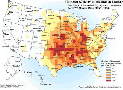
Misleading characterization 3: Great Plains = Tornado Alley
Children who see the classic, The Wizard of Oz, know Kansas has killer tornadoes. Among Great Plains states, Oklahoma is even more torn up by twisters than Kansas is. But the farther north and west one travels on the High Plains, the more rare tornadoes are. Indeed, the northern Great Plains are one of the safer places to live east of the Rockies if you are lilapsophobic.


The U.S. has at least four Tornado Alleys. The one on the Great Plains goes from north-south -- down through Nebraska, Kansas, Oklahoma, and Texas. An even deadlier alley straddles the Deep South -- extending east-west across Alabama, Mississippi, Tennessee, Arkansas, Louisiana, and Oklahoma. Note that the Great Plains state of Oklahoma is the junction of these deadly Tornado Alleys. But the farther north one goes on the High Plains, the rarer tornadoes are. Boston, Massachusetts, has far more tornadoes than Billings, Montana.  


There are far more night twisters in the Deep South's Tornado Alley than in the Great Plains' Tornado Alley.


Misleading characterization 4: Great Plains = Corn Belt
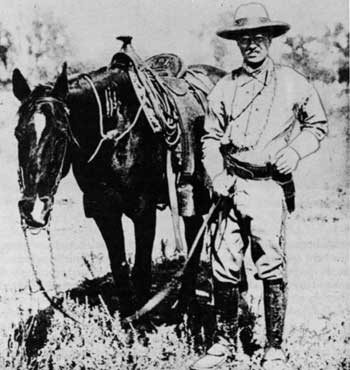
Although the Corn Palace is in Mitchell, South Dakota, corn only thrives in the bottomlands and irrigated tracts of the High Plains. True, the eastern part of the Great Plains has the climate, soil, and water to grow robust harvests of corn. Yet the High Plains are better known for spring and winter wheat. They are really part of the wheat belt because wheat can withstand arid conditions better than corn can. And because wheat grows here, there are cattle -- lots of cattle. Great Plains wheat sustained the long cattle drives after the Civil War. Not many people know that Theodore Roosevelt spent time as a cattleman on the Great Plains. Retreating from civilization after the deaths of his wife and mother on Valentine's Day, 1884, TR resigned from the New York Assembly and went to Dakota Territory where he invested in two ranches and worked as a cowboy.
Corn grows well in the eastern parts of the Great Plains, as well as in the bottomlands of the High Plains, but the region is better known for wheat and the cattle fattened by it.


Misleading characterization 5: Great Plains = Midwest
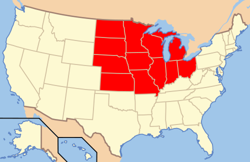
For the practical needs of the classroom, teachers break down the Continental U.S. into manageable chunks of states. Somewhat arbitrarily, they have drawn a line around a bloc of 12 states in the north-central part of the nation -- from Ohio and Michigan in the east to Kansas and North Dakota in the west -- and labeled them "the Midwest." Only four of the Great Plains states are technically in the Midwest: North Dakota, South Dakota, Nebraska, and Kansas. Even these states have more of a western than a midwestern feel, what with their rodeos and rangeland the closer one gets to the Rockies. The High Plains also extend into three states of the Southwest -- Texas, Oklahoma, and New Mexico -- as well into three states of the Mountain West: Colorado, Wyoming, and Montana. So the Great Plains stretch across three somewhat artificially designated regions. Depending on the place, one can feel the tug of the Midwest, West, and Southwest in the grasslands.

From the perspective of elementary geography textbooks, the Great Plains spread across three major geographic provinces. The Great Plains include the westernmost states of the Midwest (in red) -- North Dakota, South Dakota, Nebraska, and Kansas. This western sea of grass also stretches into parts of the Southwest and Mountain West.

*     *     *

SOURCES

For the Internet source of each photograph, map, and illustration used in this essay, click on the image.

Additional sources that I consulted are available through the hyperlinks in the text, or below.

For a bibliography of Great Plains geography, consult http://libguides.emporia.edu/content.php?pid=60124

Oklahoma is discussed at http://digital.library.okstate.edu/encyclopedia/entries/G/GR015.html


Theodore Roosevelt, cowboy
"I never would have been president if it had not been for my experiences in North Dakota."
*     *     *

This photo-essay is part of a series on Great Plains geography.

Saturday, June 25, 2011

Great Plains geography 3

The High Plains: You know 'em when you see 'em.

Comparing the seven maps that follow shows the challenge of defining the Great Plains. The first map is the most vague; the last map, the most specific. Nevertheless, each map locates the region's boundaries differently, especially its soft eastern margin that merges into the lower Central Plains and tall grass prairie.

The Interior Plains, which make up half of the Continental U.S., are divided into two parts: the Central Plains/Lowlands to the east and the Great Plains to the west. The boundary between the two parts is not distinct. But this summation holds true: The Central Lowlands' rich soils have made the region famous as America's breadbasket; the Great Plains' sea of grass became legendary for trail drives, ranches, and the cowboy cattle empire. Also the Great Plains are considerably higher in elevation than the Central Lowlands. Viewed from the Mississippi River Valley at, say, St. Louis, the plains are a plateau of sedimentary rock that rises gently west to the foothills of the Rocky Mountains. At Denver, Colorado, the land is one mile high.   


This depiction of the Great Plains shows a huge rural expanse covering almost one-forth of the Continental U.S. Lying astride the 100th meridian, the Great Plains extend over all or parts of ten states west of the Mississippi River and are part of the vast Interior Plains physiographic province.


Indigenous grassland biomes on the Great Plains include the steppe-like short grass prairie (light green) and mixed grasses between the 100th and 98th parallels. The tall grass prairie to the east (dark green) is often used to distinguish the eastern boundary of the Great Plains from the Central Lowlands. However, there are hardly any remnants of tall grass prairie left.
Another map of the North American prairie. The short grass prairie is in yellow.


Geomorphically, the Great Plains are much more complex than most Americans realize.
Visit the U.S.G.S. site http://tapestry.usgs.gov/physiogr/physio.html for a remarkable topographic map of and map key to the physiographic regions of the United States. Geologically, the High Plains, as the term suggests, are composed of numerous layers of relatively horizontal sedimentary rock that slopes gently east from the Rockies toward the Missouri-Mississippi rivers. But erosion has produced complex terrain (geomorphology), especially near larger rivers. Among the landforms on the High Plains are plateaus, mesas, buttes, hogbacks, bluffs, badlands, loess formations, moraines left by continental glaciers, and driftless plains that largely escaped glaciation. Depending on where one puts the boundaries of the region, elevations range from 7,000 feet in Colorado (the Black Forest) to under 1,000 feet in North Dakota (along the Red River) and Texas (Edwards Plateau).


This map of the grasses, crops, and other vegetation of the Great Plains extends farther east than the geologic and most geographic depictions of the Great Plains; the coniferous patch in South Dakota represents the Black Hills. Note that the region's boundaries, viewed from the perspective of agriculture and land use, extend into Mexico and Canada.


A consortium of scholars at the University of Michigan, Colorado State University, and University of Saskatchewan has defined the eastern boundary of the Great Plains with a concession: "The only agreement on this boundary is that no authoritative line exists. Numerous people have attempted to define this border in both physiographical and cultural terms, using such demarcators as the 100th, 98th, 95th, and 88th meridians; the Missouri, Arkansas, and Mississippi rivers; and various levels of annual rainfall. Our boundaries depend on a combination of climatic, topographical, political, and cartographic criteria, and are ultimately drawn along county borders. According to these definitions, the Great Plains region contains about 475 counties in twelve states."

As land use maps suggest, the Great Plains have the lowest population density east of the Rockies; in many places fewer than 2 inhabitants per square mile live there. One keenly experiences the loneliness of the land in eastern Montana, eastern Wyoming, and the western Dakotas in the U.S., and great stretches of Alberta and Saskatchewan in Canada. Their rural feel contrasts with significant cities around the perimeter of the Great Plains that serve as the region's entrepots: Fort Worth, Oklahoma City, Tulsa, Kansas City, Omaha, Sioux Falls, Fargo, Winnipeg, Saskatoon, Edmonton, Calgary, Cheyenne, Fort Collins, Greeley, Boulder, Denver, Colorado Springs, Pueblo, San Antonio, Austin, and Waco. There are also significant cities within the Great Plains, but on average they are smaller than the perimeter cities. The interior cities include Moose Jaw, Regina, Billings, Minot, Bismarck, Rapid City, Pierre, Lincoln, Wichita, Abilene (Kansas), Topeka, Amarillo, Lubbock, Midland, Odessa, Abilene (Texas), and Roswell.


*     *     *

This photo-essay is part of a series on Great Plains geography.