 |
| The loneliness of the land: Rick Dunn's photograph of the Pawnee Buttes, east of Fort Collins, Colorado. Although Colorado is regarded as the Rocky Mountain state, almost half of it extends into the Great Plains. (See Rick Dunn's essay that accompanies this photo.) |
The best synonyms for the "Great Plains" are "High Plains" and "western sea of grass." James Fenimore Cooper referred to the region as "the Great Prairies west of the Mississippi" [The Last of the Mohicans, 1826, Introduction]. Other synonyms are sometimes used in popular parlance but they don't work well:
Misleading characterization 1: Great Plains = Great American Desert
The Great Plains go through periodic droughts that seem to turn the region into a wasteland. West Texas is experiencing such a drought as I write. [See article here.] But humans have also contributed to the catastrophes of the last 150 years, especially because of the over-extension of grazing and of deep plowing. As a result, ordinary drought cycles such as occurred in the second half of the 19th century were magnified during the first half of the twentieth century. One catastrophe was the so-called Dust Bowl. Such catastrophes are relatively rare. In most years since Anglo-American encroachment, the Great Plains have received adequate rainfall during the growing season to support a harvest of wheat. The eastern part of the region is wetter, an ecological garden, a veritable breadbasket. So where did the term, "Great American Desert," come from? In 1819 President James Monroe sent an American explorer named Stephen Long to explore the west. He trekked through the Great Plains in a dry spell and believed the land was inhospitable, and so labeled the region west of the 98th Meridian the Great American Desert. The moniker lasted from the 1820s to the 1870s. It's another way an early president of our nation had a surprising impact, this time on the perception of the Great Plains.
 |
| Major Stephen Long's 1820 map of the "Great American Desert." The Great Plains comprise the easternmost third of the arid Great American Desert and Great Basin. |
 |
| Dust Bowl |
Misleading characterization 2: Great Plains = the prairie
It would be more accurate to say that the Great Plains = shortgrass prairie. As the map below shows, the vast prairies of North America are not coterminous with the Great Plains but extend considerably to the east of the region. At the time of Columbus, the famous "prairie wedge" speared east of the Mississippi River into Illinois. In addition, there were numerous prairies islands east of the Mississippi River. But Illinois's prairie wedge and the prairie islands farther east should not be considered High Plains. Note on the map below the curious extent of prairie in Michigan, where tallgrass prairies thrived in glacially deposited, sandy, outwash plains in Newago County where the Muskegon River flows. Eventually it morphed into the so-called Big Prairie Desert because of the extent of sand and sparce vegetation. It is misleadingly regarded as the largest "desert" east of the Mississippi River.
 |
| Extent of indigenous shortgrass prairie (light green), mixed prairie grasses, and tallgrass prairie (dark green) at the time of Europeans' arrival in the Americas. A safe generalization is that the eastern extent of the Great Plains began where the tallgrass prairie ended. The climate is wetter where the tallgrass prairie thrives, and drier where the shortgrass prairie grows. |
Misleading characterization 3: Great Plains = Tornado Alley
Children who see the classic, The Wizard of Oz, know Kansas has killer tornadoes. Among Great Plains states, Oklahoma is even more torn up by twisters than Kansas is. But the farther north and west one travels on the High Plains, the more rare tornadoes are. Indeed, the northern Great Plains are one of the safer places to live east of the Rockies if you are lilapsophobic.
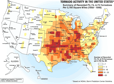 |
| The U.S. has at least four Tornado Alleys. The one on the Great Plains goes from north-south -- down through Nebraska, Kansas, Oklahoma, and Texas. An even deadlier alley straddles the Deep South -- extending east-west across Alabama, Mississippi, Tennessee, Arkansas, Louisiana, and Oklahoma. Note that the Great Plains state of Oklahoma is the junction of these deadly Tornado Alleys. But the farther north one goes on the High Plains, the rarer tornadoes are. Boston, Massachusetts, has far more tornadoes than Billings, Montana. |
 |
| There are far more night twisters in the Deep South's Tornado Alley than in the Great Plains' Tornado Alley. |
Misleading characterization 4: Great Plains = Corn Belt
Although the Corn Palace is in Mitchell, South Dakota, corn only thrives in the bottomlands and irrigated tracts of the High Plains. True, the eastern part of the Great Plains has the climate, soil, and water to grow robust harvests of corn. Yet the High Plains are better known for spring and winter wheat. They are really part of the wheat belt because wheat can withstand arid conditions better than corn can. And because wheat grows here, there are cattle -- lots of cattle. Great Plains wheat sustained the long cattle drives after the Civil War. Not many people know that Theodore Roosevelt spent time as a cattleman on the Great Plains. Retreating from civilization after the deaths of his wife and mother on Valentine's Day, 1884, TR resigned from the New York Assembly and went to Dakota Territory where he invested in two ranches and worked as a cowboy.
 |
| Corn grows well in the eastern parts of the Great Plains, as well as in the bottomlands of the High Plains, but the region is better known for wheat and the cattle fattened by it. |
Misleading characterization 5: Great Plains = Midwest
For the practical needs of the classroom, teachers break down the Continental U.S. into manageable chunks of states. Somewhat arbitrarily, they have drawn a line around a bloc of 12 states in the north-central part of the nation -- from Ohio and Michigan in the east to Kansas and North Dakota in the west -- and labeled them "the Midwest." Only four of the Great Plains states are technically in the Midwest: North Dakota, South Dakota, Nebraska, and Kansas. Even these states have more of a western than a midwestern feel, what with their rodeos and rangeland the closer one gets to the Rockies. The High Plains also extend into three states of the Southwest -- Texas, Oklahoma, and New Mexico -- as well into three states of the Mountain West: Colorado, Wyoming, and Montana. So the Great Plains stretch across three somewhat artificially designated regions. Depending on the place, one can feel the tug of the Midwest, West, and Southwest in the grasslands.
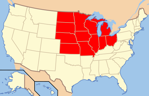 |
| From the perspective of elementary geography textbooks, the Great Plains spread across three major geographic provinces. The Great Plains include the westernmost states of the Midwest (in red) -- North Dakota, South Dakota, Nebraska, and Kansas. This western sea of grass also stretches into parts of the Southwest and Mountain West. |
* * *
SOURCES
For the Internet source of each photograph, map, and illustration used in this essay, click on the image.
Additional sources that I consulted are available through the hyperlinks in the text, or below.
For a bibliography of Great Plains geography, consult http://libguides.emporia.edu/content.php?pid=60124
Oklahoma is discussed at http://digital.library.okstate.edu/encyclopedia/entries/G/GR015.html
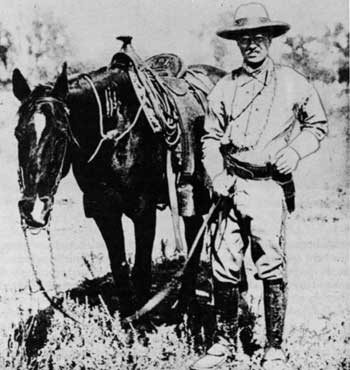 |
| Theodore Roosevelt, cowboy "I never would have been president if it had not been for my experiences in North Dakota." |
* * *
This photo-essay is part of a series on Great Plains geography.
Ayok Merapat kepada Kami hanya Di @BOLAVITA Www.Dewasabungayam.com
ReplyDeleteNice INFO
ReplyDeleteMau bonus ? klik disini ya ayam jago bangkok
ReplyDeletemau yang asik ? adu ayam
ReplyDeleteArtikel yang sangat bagus ^_^
ReplyDeleteM88 Bola
M888 Bola
Bagi para penggemar Judi Online Jangan Lupa Kunjungi http://112.140.186.67 .
Situs Grandm88 Taruhan Bola Terpercaya Di Indonesia Menyediakan Banyak Jenis Permainan Diantaranya :
SBOBET
Sabung Ayam
Casino Online
Slot Game
Mix Parlay
Bola Jalan
Grandm88lounge.com Merupakan Portal Berita Bola, Jadwal Bola, dan Prediksi Parlay Terupdate Setiap Harinya..
Prediksi M88
Prediksi Bola
Taruhan Bola Terpercaya Diseluruh Indonesia
Agen Togel Online
ReplyDeleteAgen Togel
Agen Togel Singapura
Museumbola Slot IDN
Museumbola Slot Habanero
Museumbola Joker123
AKSES SEGERA SITUS KAMI 1 ID BANYAK PERMAINAN
WA OFFICIAL : +6283157394921